Oldest among the maps on which Iceland is shown is the Anglo-Saxon map, which is believed to have been made somewhere around the year 1000. If that dating is approximately right, this is the first known occurrence in writing of the name Iceland. The country is shown as a long island having a general east-west direction, fairly broad at the eastern end but drawing to a point at the western end. It lies to the north-west of Scotland and somewhat closer in, is shown another island, Tylen.
Like most mediaeval maps the Anglo-Saxon map no doubt goes back to the ancient originals. The cartographer obviously had a rather shaky idea of the countries he was describing, and his picture of Iceland may in part represent general ideas about the Northern countries, especially Norway.
Iceland is shown on several mediaeval charts, and on some of them it is north-east of Britain but south of Norway. This in particular applies to maps which can be traced to English cartographers although they were not all made in England. On other maps Iceland is placed arbitrarily somewhere to the north-west or north of the disc of the earth. Sometimes it becomes identified with the mythical land of the ancients, Thule, which a Greek navigator, Pytheas of Massilia (Marseilles), visited in the 4th century B. C. Towards the latter half of the Middle Ages the prevailing belief is that the two countries are one and the same. For this reason it is extremely difficult to guess what old cartographers had in mind when they put Thule on their maps; we often do not know whether they were thinking of Iceland or the mythical country of Pytheas.
Ptolemy, or the authors of the maps attributed to him, stopped at 63° N. When these maps reached scholars in the West, they were soon found to correspond poorly to the geographical knowledge of those times. To remedy this, people before long began to augment the ancient maps with new maps of countries which in the Ptolemy maps had been left out or represented in a fashion felt to be wholly inadequate. It was the Dane Claudius Claussøn, or Claudius Clavus, who apparently led the way in this new departure; at any rate, no earlier instances are known. He made two maps of the North where Iceland is shown. The maps are now lost and known only in later copies. A copy of the older map was not discovered until early in the 19th century. It seems to have had no influence on contemporary or later maps. The younger map, which is from about 1425-1439, is preserved in several copies in Ptolemy manuscripts of the latter half of the 15th century and soon found its way into printed editions of the work. In spite of various flaws and very limited knowledge, Clavus' maps constitute an undoubted stage in the cartographic history of the countries around the North Atlantic. Iceland is given the approximately right position, although its shape and outline leave much to be desired. Clavus' importance lies in the fact that his maps provided the model for representations of the country in most printed maps up until the second quarter of the 16th century.
At the same time, probably a little later, southern sea charts begin to show a new version of Iceland. The country is actually called Fixlanda (written in several ways) which is later replaced by Frislanda. We assume the cartographers are referring to Iceland although it is not certain. The Fixlanda type suggests considerable familiarity with Icelandic local features, much more so than on the Clavus' maps, especially the two bays on the west coast and the islands in the west. The same may be said of the islands south and north of the country. There is a fair number of place names but most of them seem to be descriptive of local features and peculiarities in the landscape rather than place names in the ordinary sense of the word.
Where did cartographers on the shores of the Mediterranean come by this information about Iceland and Icelandic local conditions? Their only possible informants would seem to be the English, who began sailing to Iceland on a large scale during the first years of the 15th century and continued to do so throughout the century. Along with their Iceland voyages the English carried on extensive trade with Spain and Portugal. Catalan mapmakers and those who followed in their footsteps continued to show Fixlanda virtually unchanged on their charts until the end of the 16th century and even after that. The position of Fixlanda seems later to have had a decisive influence on the placement of Iceland on Portuguese and French marine charts in the beginning of the 16th century. These maps are often called the Dieppe maps and their representation of Iceland remained unsurpassed until the appearance of bishop Gudbrandur Thorláksson's map some 70 years later.
In the year 1532 Jacob Ziegler published in Strasbourg a book with the kind of enormously long title fashionable in those days. The book has a section on the Northern Countries which is entitled Schondia, and the book as a whole is frequently referred to by that name in works on the geography of the North. One of the maps in the book shows the countries around the Baltic and the North Atlantic. Scandinavia is changed for the better and represented approximately correctly, as a peninsula with a general direction from north to south, rather than from east to west as on older maps. Ziegler does not, however, appear to have been particularly well informed about Iceland which is a long and relatively narrow island with a general north-south direction. Many cartographers adopted Ziegler's type of Iceland to a greater or less extent, fitting it into its surroundings in various ways. Still, it never became as prominent or as influential as the Clavus type, nor was it granted the time necessary for that. Only seven years were to pass before the appearance of Olaus Magnus' map of the North, which was far more detailed and superior in many respects and gradually pushed maps of the older types to the side.
The year 1539 is an important year in the cartographic history of the North. In this year Olaus Magnus, a Swedish ecclesiastic, who ultimately became titular archbishop, published his map of the North, Carta Marina, which was printed on nine sheets and ranked among the largest maps yet made. The shape of Iceland is mainly oval and the direction is from south-west to north-east. Most of the place names are of Icelandic origin, in contrast to those on the South-European maps. The ocean in Carta Marina is provided with number of whales, monsters and ships but inland we see pictures from national life and nature. It has been suggested that Olaus might have spoken to Iceland voyagers in the seaports of Northern Germany and the Netherlands, from them he could have picked up knowledge of many sorts.
In 1541 Gerhard Mercator put out a new globe, on which he had been working "one or two years." It is generally believed that Mercator here followed the maps of Ziegler and Olaus in his representation of Iceland and Scandinavia, but the difference in scale, especially between the globe and the huge Carta Marina, makes comparison extremely difficult. Although Mercator's type of Iceland bears a considerable resemblance to that of Olaus, the difference between them are great enough to make it seem unlikely that Mercator was following the Carta Marina. More probably each map represents an independent utilization of the same or similar sources, which both authors happened to come across, probably in the Netherlands or Germany, and are now lost or unknown. Supporting this is that on later maps (1554 and 1569) Mercator includes practically all the detail found on Olaus' map but not on his own globe.
One of most famous copies of Olaus' map is the Zeno map which appeared in 1558 as a part of a book by Nicoló Zeno. The book purports to be a retelling of the exploits of an ancestor and his brother, during their voyages in the North Atlantic and westward to the shores of America towards the close of the 14th century. The map, which is of the North Atlantic and the countries bordering it, is supposed to be contemporary with the events recounted in the book. It is now known that the narrative was manufactured by the younger Zeno himself not long before the publication of the book, and the same is true of the map. Its principal sources are Olaus Magnus´ map and old maps of the North of the Clavus type with elements taken from southern sea charts of the 15th and 16th centuries (the Fixlanda maps). The Zeno map would probably not have been long lived if Gerhard Mercator had not adopted a number of its principal features for his world map of 1569.
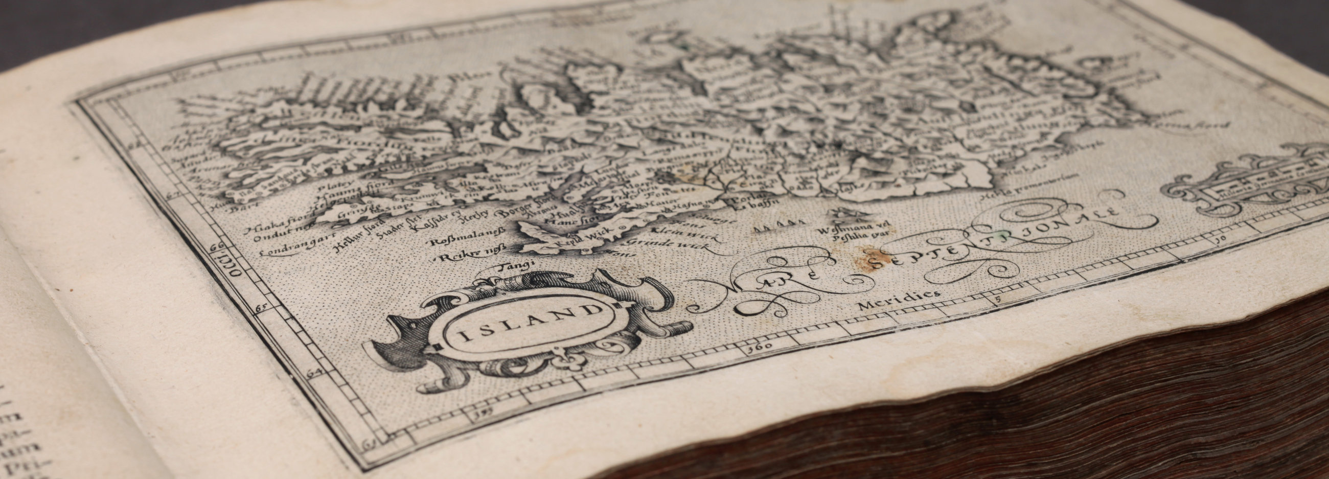
Olaus' and Mercator's maps of Iceland were quick to become the dominant ones and were closely followed by many cartographers throughout the 16th century and into the 17th. One of them was Abraham Ortelius who began in 1570 to publish his atlas Theatrum orbis terrarum. It includes three maps showing the North Atlantic region in Mercator's version of the Zeno map, some of which reappear in all editions of the work up to the year 1612. Many scholars copied or imitated these and other maps of Ortelius. He was later the first cartographer to publish the new version of Iceland by bishop Gudbrandur Thorláksson.
It is not known when bishop Gudbrandur made his map because it is rarely mentioned in Icelandic sources, but it appeared for the first time in the year 1590 in a new supplement (Additamentum IV Theatri orbis terrarum) to Abraham Ortelius' atlas. It was not altogether new, since on it says that it was engraved in 1585. The author is not mentioned, but the map is dedicated to Fridrik II of Denmark by Andreas Velleius (Anders Sørensen Vedel, 1542-1616), a well known Danish historian of the period. Ortelius´ map was for a long time attributed to him, although even in the time of bishop Gudbrandur it was known that he was not the author. Ortelius seems to have received the map directly from Vedel's own hands, and probably it never occurred to him that Vedel was not the author. Five years later (1595) the map appeared again in somewhat different version in Atlas sive cosmographicæ, the last edition of Gerhard Mercator's Atlas. The maps were published in many editions of the collections of Ortelius and Mercator.
We do not know what resources Gudbrandur had at his disposal. As a native of the country he of course was more familiar with it than foreign cartographers. There exist lists of churches and fiords which he seems to have used, especially the latter, which he follows very closely for a large part of the coast. There is nothing that points to any surveying or calculating of latitude and longitude being done.
Although the map is faulty in many ways, it is far superior to all earlier maps of Iceland in content and execution. Here for the first time we find a map giving a more or less complete survey of all settlements in the country and most places of interest.
It fell to Joris Carolus of Enkhuisen, a Dutch navigator and traveller in the North, to produce the most stable and durable version of the position and shape of Iceland, not only on maps made in Holland, but wherever people tried to form some picture of the country and display it on a map. More than a century passed before cartographers had access to newer and more reliable information about the country. Joris Carolus probably made his map in the 1620s and it shows the influence of both versions of bishop Gudbrandur's. The coastline resembles more the version of Ortelius, but when it comes to place names the map follows Mercator in selection and spelling. The map of Carolus was printed in many editions of the collections of two of the largest map publishers in the Netherlands, Willem Janszoon Blaeu and Johannes Janssonius.
Thórdur Thorláksson, later bishop of Skálholt, made three maps of Iceland when he was studying in Copenhagen, the first two in 1668 and the third in 1670. The basis for all three is the map by bishop Gudbrandur. The width of the country is reduced and brought nearer to a reasonable size, but bishop Thórdur's maps fell victim to the same forces which for a long time both before and after determined the fate of cartography in Denmark: they were put to one side, lost sight of, and thus were no benefit to anyone.
At this time the Danes maintained a monopoly of trade with Iceland. Their trading operations in Iceland made it necessary for the Danes to become rather more familiar with the country, not least with regard to suitable harbours and trading centres. The Danish government decided therefore in 1651 to send Bagge Wandel to Iceland to take soundings and survey possible harbours. It is not known what the outcome was, but there are no charts of his to suggest that he ever went. The 17th century thus passed with no further action.
In the first decade of the 18th century there comes on the scene Hans Hoffgaard. Little is known of his career, but it is likely that he was employed by the Danish trade mission. He left behind 20 charts of harbours scattered around the coast, as well as two maps of the whole country. From about the same time, or 1721, is the map of Iceland by Peter Raben. His map has many gaps and it is likely that it was never finished.
Raben took over as governor of Iceland in 1720, and in the very first despatch which he wrote to the king he points to the need for an accurate map of the country. A little later he put before the king proposals for carrying out the task. The king approved these in broad outline, and in the spring of 1721 Magnús Arason was given the job. Magnús was an Icelander who had for a time worked as an engineer in the Danish army. He began his survey the following summer and carried it on for the next seven summers. He was drowned in 1728 and had by then completed surveying from Reykjanes to Arnarfjördur and made a map of each county separately. Magnús was instructed to survey nearly all of the country but in view of the provisions made for equipment and help by the way, there was no chance that any one man alone could carry out all this to any purpose.
Following the death of Magnús Arason, the Danish government sent a Norwegian expedition to Iceland in 1730 under the leadership of Thomas Hans Henrik Knoff to continue and complete the work. The government must have realised that there was no longer any question of employing one man to do the work alone. In five years they had completed the work left undone by Magnús and corrected his maps to some extent, where it seemed necessary. They also made seven maps of specific districts and an overall map of the whole country: Siø og Land Carte over Island ... MDCCXXXIV.
When the maps were brought to Copenhagen a dispute began over them and they were put away under lock and key in some government department, where they lay unpublished and forgotten by nearly everyone for many years. In 1752 a rather poorly done copy of the Knoff map of 1734 accompanied the book Tilforladelige Efteretninger om Island by the Danish scholar, Niels Horrebow. A better copy appeared in 1761 by the distinguished firm of mapmakers, Homanns of Nürnberg (Die Homännischen Erben), entitled Insvlae Islandiae delineatio. Jón Eiríksson and Gerhard Schøning made a copy of the Homanns map which was published 1772 in the travel book by Eggert Ólafsson and Bjarni Pálsson.
For the next 50 to 70 years most quality maps of Iceland were based more or less on the map by Jón Eiríksson and Gerhard Schøning. Sometimes it is difficult to see whether the model is the map in the travel book or the older versions of the map by Knoff, the maps by Horrebow and Homanns.
In the years 1771-1772 the French government sent a scientific expedition to the North Atlantic. It was led by Verdun de la Crenne and its commission was to explore the ocean, the coasts, and the islands on their route. They reached land in the Western Fiords and made numerous observations there, measured the latitude and longitude, and took some soundings. When they saw the results of their measurements they decided to move the west coast nearly three and a half degrees eastwards, though without disturbing the longitude of the east coast to any extent but the expedition never went there. This doubtful result was then the basis of the representation of Iceland on the French chart of the North Atlantic: Carte réduite des Mers du Nord ... 1776. The map was farther from the truth than previous maps.
The two versions, Knoff and Verdun de la Crenne, were for a long time rivals for acceptance, and for a while the latter had the best of it. This caused considerable confusion in people's ideas of the country. Both versions held their own until almost the middle of the 19th century, when they were compelled to make way for new ones stemming from the coastal surveys of 1800-1819 and the maps of Björn Gunnlaugsson.
Although the Knoff maps were an improvement from the map of bishop Gudbrandur they were not good enough and the authorities must have realised that a new survey of the country was needed. It was a serious inconvenience to the trading companies not to be able to find anywhere information as to the most suitable and safest entries to the various harbours. In 1776 an experienced Danish captain in the service of the trading company was sent to Iceland, Hans Erik Minor by name. His task was to survey all the coasts and harbours, and investigate the fishing grounds and everything else involved in the preparation of charts. Minor worked for two summers, by which time he had completed his survey of the area from Reykjanes via Faxaflói and the northern part of Snæfellsnes as far as Stykkishólmur. He returned to Iceland in 1778 intending to continue work, but drowned in Hafnarfjördur shortly after his arrival. The charts Minor had completed were published in 1788 along with the accompanying description of the coasts.
The publication of Minor's charts marked the end of an important chapter, and applied to precisely those regions where most sailing could be expected. But there was still a long way to go before the projected task of surveying and charting all the coasts of the country was completed. It was not until the year 1800 that the work was continued and nearly twenty years later (1819) it was completed. It were mainly Norwegian captains and surveyors who did the work. The maps were published during the years 1818-1824 by the founder of the Danish Hydrographical Office, Poul de Løvenørn. The charts were accompanied by three volumes of pilot's instructions. In the year 1826 there appeared an overall map of the coast of Iceland. With a few changes, the picture of the country which appears for the first time on these charts is the one we know today, though of course later maps are more exact.
Although the coastal charts were an important step forward, there was still a long way to go before the target was reached, a satisfactory map of the whole country, both inhabited and uninhabited. The coastal charts were probably enough for sailors, given the conditions and standards of the time, but they were of less use to the Icelanders themselves, either as regards general knowledge of the country or for general purposes. By a fortunate coincidence, it happened that a man was to be found in Iceland who had taken a degree in mathematics and worked for a time as a surveyor abroad. This man was Björn Gunnlaugsson, a teacher at the grammar school at Bessastadir. When it was decided to survey the whole country the task was naturally entrusted to him.
Björn worked on the survey during the years 1831-1843, excepting the summer of 1836. The Icelandic Literary Society made him an annual grant and in 1836 the financial position was also eased when the Danish government made him a grant of 100 rix-dollars which he continued to receive until 1846. The original idea was to survey each county individually and make separate maps, but in the event it was felt impractical to undertake such a large task on account of the cost. O. N. Olsen was appointed to attend to the publication of the maps in Copenhagen. He had taught at the military academy and was considered particularly well qualified to deal with surveying and mapmaking. He proposed that the map should be printed on four sheets. It was his task to take the maps of the separate counties and regions as they arrived from Björn Gunnlaugsson, and then join them together and reduce them. Björn Gunnlaugsson's map, Uppdráttr Íslands, is usually dated from 1844, although no part of it probably was completed until four years later (1848).
In the course of his survey Björn covered virtually the entire inhabited area and a good part of the uninhabited. His principal concern was to map the inhabited regions, leaving a complete map of the rest of the country until a better opportunity. The central highlands, therefore, were still rather left out, although it was a great advance on previous maps. It was not until the geological map of Þorvaldur Thoroddsen was printed in 1901 that we see a proper picture of the central highlands.
There are of course more inaccuracies in Björn's maps than one would wish, but if he had attempted a more precise survey, he would never have been able to finish the task. It was better to relax demands where exactness was of less importance. It might be a long time before another survey would be undertaken with a view to a map of the whole country. In spite of some errors, Björn Gunnlaugsson's survey and map are a great scientific achievement, unique of its kind, carried out with extremely limited resources both in finances and equipment.
For the next 50 years most maps of Iceland were based more or less on the map by Björn Gunnlaugsson. It wasn't abandoned completely until after World War II when new maps based on new surveys appeared on the scene.
(Haraldur Sigurðsson: "Ísland á landabréfum. Nokkrir drættir". Kortasafn Háskóla Íslands. Reykjavík 1982, p. 7-15. Slightly abbreviated and translated into English).